Calculation of the Radar Coverage
for a Specific Image Area
Coverage
calculations are calculated for only one path (depicted in red)
segment. Black is the entire radar
path. Blue is the outline of the
image area The other choice is the radar coverage
as a function of Computational Increment (CI) position within the image area. First the radar positions that illuminate
at least one CI are determined and grouped into continuous radar path
segments. Finally, the percentage
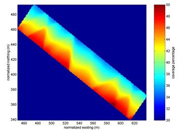
of all the selected radar positions that illuminate each CI is also calculated. Variation of coverage
is due to variations of roll, pitch and heading of aircraft, as shown here:
Coverage as a function of position within image area (shown in
blue in the figure on the left)
![]()